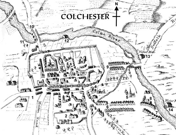
| |
WITHIN THE WALLS
|
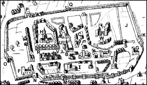
This is a clickable imagemap. |
|
A |
St. Martin's
The tower and some minor elements date from the 12th century, while
much of the rest of the fabric is late medieval. There are some
reasons to think there may have been a church on the site in late
Anglo-Saxon times, perhaps even as far back as the end of the Roman
occupation. |
|
B |
St. Runwald's
Likely of late Saxon origin, judging from the dedication, although its
central placement without any surrounding churchyard suggests that it
was an intrusion into an already built-up area. Before it lay the main
market of the borough, and the medieval shambles were adjacent. Demolished
1878. |
|
C |
St. Helen's chapel
Local legend – perhaps inspired by the impressive Roman walls – had
Helen as a daughter of the mythical King Coel, ruler of Colchester, and
as the mother of the Emperor Constantine. Neither has historical
foundation; but more significantly St. Helen became viewed as patron
saint of the town – her image was featured on the community seal.
The same medieval tradition had the chapel being restored in 1076 by Eudo
the Steward; if true, this might suggest an Anglo-Saxon origin, and there
is some indication the chapel was built atop the remains of a Roman
structure. Eudo gave it to the Abbey as part of his foundation
endowment. In 1290 the Abbot was
convicted of neglecting to provide a chaplain to celebrate in the chapel
during part of each week. Perhaps in part because of the resulting
impoverishment of the chapel, in 1320 John de Colcestre, the rector of
Tendring (apparently a member of a prominent
burgess family), endowed a chantry there with numerous rents and land
to support a chaplain, and made the bailiffs and community the effective
patrons; they subsequently placed the chantry under the administration of
the Gild of St. Helen's (a fraternity of which many leading townsmen, as
well as some county dignitaries, were members) although retaining control
over presentments. |
|
D |
St. Nicholas
In existence at least by the 12th century, but rebuilt in the 14th, and
again in the 1870s, finally to be demolished in 1955. Parts of the
church had Roman walls for their foundation, although the Roman structure
was probably secular, not ecclesiastical. |
|
E |
All Saints
There remains minor evidence of Norman work in the church, although it is
not impossible that there was an even earlier church, given the location
and the incorporation of brickwork from an even earlier Roman structure
(this part of town being the forum/basilica). It was expanded in the
14th and 15th century, with a tower and other additions. |
|
F |
St. Mary's-at-the-Wall
Built on the site of a Roman house, with the original church perhaps of
Saxon date (judging from burials in the vicinity), it may have been
created as, or come to be, the private church of an estate of the Bishop
of London (a soke outside the jurisdiction of borough authorities).
Joseph Elianore obtained royal
licence in 1338 to found a chantry there which during the 1340s he endowed
with numerous lands and rents. The earliest known school in Colchester was
located here in the 15th century. The church's proximity to the wall made
it a defensive position, and target for the besiegers, in 1648. It was
ruinous when rebuilt in the next century, to be demolished (except for
its tower) in 1872. |
|
G |
St. James
A church stood here from at least the 12th century (although that may
have been a rebuilding of an earlier structure). There was further and
substantial rebuilding in the 15th century. |
|
H |
St. Peter's
The only Colchester church mentioned by name in Domesday, when evidently
already well-endowed with lands. It's key position near the junction
of two major streets also indicates its importance in the town. The
surviving medieval fabric is, however, 15th century. The depiction in
1648 still reflects the medieval cruciform plan of the church, with
a prominent tower (replaced in the 18th century) at the centre. |
|
I |
Holy Trinity
It still has its Saxon tower, dating to ca.1000, constructed in part from
brick and tile from Roman structures; there is evidence that part of the
church dates even earlier. Parts were rebuilt in 14th and 15th
centuries. |
|
J |
Grey Friars
This Franciscan priory, whose grounds occupied the north-east corner of
the land within the walls, was founded before 1279, and possibly
by 1237. Little has been found by way of remains. |
|
K |
East Gate
Badly damaged during the siege of 1648, the remains were torn down a
few decades later. |
|
L |
Botolph's Gate
Destroyed in 1823. |
|
M |
Schere Gate
A postern. |
|
N |
Head Gate
Removed 1756. |
|
O |
Balkerne Gate
The western entrance to the walled city during Roman times (remains of
the Roman gateway still stand), it fell out of use towards the end of
the Roman period and was subsequently blocked; the road leading there
from East Gate was thereafter stopped at North Hill, with traffic being
diverted to the Head Gate as an exit to roads leading westwards and to
London. The Balkerne gate was in later times thought to have been a
fort. It was once thought that a postern gate existed further south
in the western stretch of wall near St. Mary's, and may have been used
as entrance/exit during medieval times; but this was subsequently
discovered to have been only an opening for a drain to pass through
the wall. We can therefore conclude that the map's creator is
depicting the Balkerne. |
|
P |
North Gate
|
|
Q |
North Schere Gate
|
|
R |
High Street
This east-west route was the main one through the town; it ran along
the crest of a ridge. As the centre of the town, it was the site of
various markets specializing in particular goods. The point marked by
the "R" was the site of the medieval corn market. |
|
S |
East Street
|
|
T |
Botolph Street
Site of the fair held at the opening of oyster season. |
|
U |
St. Martin's Lane
The Jewish quarter was primarily focused here, nearby market and
castle. |
|
V |
Moothall
It is curious that this is not identified on the map. It was destroyed
in 1843, when Norman doorway and arches were discovered therein (before
being pulled down). Later town halls were built on top of the site. |
|
W |
Castle
Medieval tradition held that the castle
had been built atop the foundations of King Coel's castle. It has been
suggested that this might reflect the former occupation on
part of the site by the residence of an ealdorman or even an East Essex
king.
|
 History of
medieval Colchester
History of
medieval Colchester