When fortifications were created around the town it was initially
along the line of the existing sea bank, by this time well east of the
actual line of the riverbank. Since the built-up area
of the town was in the eastern half of the territory between the river
and the sea bank (i.e. concentrated closest to the river), there was
land available in the western half for pastures, orchards, mills, or
for the monastic complexes of the various orders of
friars which established themselves in Lynn in
the thirteenth century. In the fourteenth and fifteenth centuries,
progressive reclamation of land from the river (by silting, dumping of
refuse, and building over the river edge) allowed wealthy merchants to
establish their complexes along the westward-shifting river's edge or
along the banks of the Millfleet or Purfleet, which gave access to and
from the river. A few of the
later
examples survive today and are among the architectural treasures
which give parts of modern King's Lynn a sense of the town at the close
of the Middle Ages.
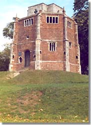
Some surviving ecclesiastical architecture
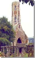
[left] A 15th century tower of the Franciscan friary;
the Franciscans established themselves in Lynn in the 1260s,
occupying a site between St. Margaret's and St. James'.
[right] The Chapel of Our Lady at the Mount
(commonly known as Red Mount), built 1483,
lay just outside the eastern defensive perimeter.
photos © S. Alsford
For many townsmen a single property served as the owner's
home
and place of business. A merchant complex was typically a long and
narrow plot of land on which was built a combination of residence,
shop, warehouse and private quay; sometimes the property was divided
by a street, so that the quay and associated buildings were adjacent
to the water while the residence was on the opposite side of the street,
but in most cases all the buildings lay between street and waterway. Plots
usually had their narrower side facing the street; this side might be up
to 50 feet wide in the thirteenth century, but by the fifteenth when there
was greater demand for frontage (at least in certain parts of the town)
30 feet was a more normal width. However, despite some measure of planned
creation of the town, there is no evidence of an attempt at any time to
standardize the size of building plots. The largest holdings might take
the following layout:
- one or more shops would front the street, while above them
and often extending out over the street
would be living/sleeping chambers (known as solars, because likelier to
take in sunlight through the windows);
- the merchant's hall (the focus for cooking and dining),
parlour, and other residential rooms, would lie behind these;
- further back, in the centre part of the property, surrounding a narrow
courtyard (which both provided access to the various parts of the building
and acted as a light-well), were storerooms and other buildings serving
purposes such as brewhouse, bakehouse and stable;
- finally, at water's edge were warehouse and quay.
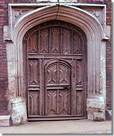
Thoresby College doorway
The college was built ca.1510, a testamentary
foundation of Thomas Thoresby, sometime mayor
and member of a leading burgess family. The style
of the doorway is very similar to those of the
15th century.
photo © S. Alsford
More moderately sized
properties – particularly those elsewhere than the waterfront, and
particularly as street frontage was reduced in width towards the end of
the Middle Ages – owned by lesser merchants or well-to-do craftsmen might
comprise one or more retail shops and/or industrial workshops facing the
street, with living quarters above; often as a later addition, halls
were built behind the shop/solar and more utilitarian structures further
back, with a narrow passageway leading off the street, under the front
range of buildings, and down one side of the plot to give access to the
structures further back. Lesser craftsmen or retailers would probably
have made do with just a shop/solar structure. Since dwellings of the
poorer townspeople were the most likely to be of flimsy construction,
subject to deterioration and later replacement, we know little of the
living conditions of that group, although documents refer to cottages
which were probably small, single-room residences of the lower strata
of borough society.
Another part of King's Lynn's architectural heritage are two of the
halls
built by medieval gilds of the town,
along with the buildings serving as the
base
for the Hanse merchants in Lynn, known
as the steelyard. The gilds, as organized
instruments of interest groups within the
community, played an important part
in building and/or maintaining public facilities. Most striking is the
hall of Holy Trinity Gild, which was
apparently the successor to the Merchant Gild authorized by the 1204 charter.
By the late thirteenth century it had a meeting hall in the Saturday
Market, naturally enough, near St. Margaret's. This was gutted by
fire in 1421 and a new hall was constructed (using brick) at a different
location, in the northwestern corner of the market; the Gild spent over
£200 on this project during the following two years.
The side facing out into the market was decorated with a chequered
pattern of black and white squares of flint and a large arched
window. The hall was used not only by Trinity Gild but rented for
meetings by other gilds and by the borough corporation (which by the
1360s was employing a caretaker of the gildhall, who also served as
bedeman, an office involving public announcement of the death of Gild
members – this being an indicator of the close link of Gild and borough).
Trinity Gild had a significant role in the life of the community, not only
by representing the interests of most leading members of that
community (the merchants), nor only by its traditional
association with town government, but
also by its management of the Common
Staith, its provision of charitable services, its contributions to
maintenance of public facilities (e.g. water
conduits) and churches, and the availability of its treasury for
commercial or public loans.
Holy Trinity Gildhall
(facade on the northwest corner
of the Saturday market),
the seat of medieval borough government.
photo © S. Alsford
For an artist's impression of how the
Guildhall might have looked when first
built, see
here
Both Trinity Gild and the Bishop contributed to the construction of
Lynn's defences, which were as much to control the access-points of
traders into the town and to define the area of borough jurisdiction
as to protect from attack. The sea bank pre-existing the town
provided a natural line of defence and was made more effective by
digging a ditch on its outward-facing (east) side; the ditch later
became part of the canal system. There is evidence for a lesser
ditch on the townward side of the bank, although this may have been
only to furnish soil to raise the bank. This activity is suspected
to have taken place in the context of the civil war at the close of
the reign of King John, when Lynn appears to have experienced a
direct threat. There were also four wooden towers: two stood at
the southern and northern ends of the Newland river bank (thus also
guarding the entrances to the Purfleet
and the Gay, respectively),
and the other two likely at the northern and southern ends of the
ditch/bank guarding the east-west road
into Newland and the south-north road into South Lynn respectively;
their date of creation is uncertain, although the
Bishop's Bretask (the tower by the Gay)
is heard of by 1270.
Royal grants of murage were obtained
by Lynn in 1266, 1294, 1300 and 1339, the baronial wars doubtless providing
the first impetus for upgrading defences to a
stone
wall. Wall construction began on the eastern boundary of Newland, with
a stone gate built where the east-west road and the wall intersected. The
question of boundary definition was another point on which town authorities
and the Bishop – through his tenants of the adjacent manor of
Gaywood – came into dispute. The townsmen had used the wall to
extend their boundary eastwards beyond the earlier line of the
sea bank, in order to encompass a suburb which had arisen east
of the bank. The southern entrance to Lynn, through South Lynn,
was likewise strengthened with a
stone
gate before 1319. The South Gate
and East Gate, possibly successors to
bretasks on those sites (certainly in the late 1360s a connection is made
in the borough records between the south gates and a South Bretask), had
gatekeepers in the Late Middle
Ages and were seen as the main entrances to the town;
other gates lying
between these two, probably built in the same period, were secondary
points of access into the town, and were kept locked at night. The stone
wall was not extended south from Newland, to protect central and South
Lynn, until the post-medieval period. Various of the watercourses
already mentioned were part of the town's defensive system. The
River Gay was the town's northern boundary and defence; a gatekeeper
was less regularly employed by the borough for a gate guarding the
bridge across the Gay, at Dowshill.

 History of
medieval Lynn
History of
medieval Lynn
