Encyclopedia | Library | Reference | Teaching | General | Links | About ORB | HOME
 History of
medieval Maldon
History of
medieval Maldon| Maldon at the close of the Middle Ages |
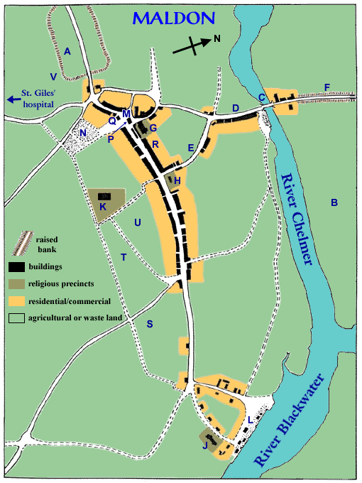 |
| This is a clickable imagemap. |
|
NOTES:
The starting-point for producing this map were several maps produced by
W.J. Petchey in his Ph.D thesis on post-medieval Maldon.
|
|
| A |
Ramparts Recent archaeological evidence has identified a small Roman settlement between the Chelmer and Blackwater. This led to a reinterpretation of what had previously been assumed to be the earthern ramparts of Edward the Elder's burh. The two are not incompatible: if Edward found the remains of Roman defences near the local settlement (by that time relocated from the Roman site, which had succumbed to the spread of marshland), it would have been logical enough to strengthen the perimeter to create a refuge for the community. The road running westwards through the ramparts led to Chelmsford. |
| B |
Portman Marsh This meadow, in the vicinity of the site of the Roman settlement, served as pasturage for horses, cows and other animals of the townspeople. There was also at least one lime-kiln here (the noxious nature of kilns making them unsuitable for location near human habitation). |
| C |
Maldon Bridge Although the surviving borough records refer to this timber bridge by the name of "pontmeldon", the name of the street leading up to it indicates that it was earlier – as far back as Saxon times, judging from the etymology of the name – known as Fullbridge. In the late Middle Ages, there was a toll for crossing the bridge of 1d. per cart or packhorse carrying merchandize. |
| D |
Fullbridge Street This led down the hill from the marketplace to the Maldon Bridge. Possibly also known as Stone Hill at one time. |
| E |
Peter's Lane I am not certain of the location of this, but it connected the high street with Fullbridge Street, passing by St. Peter's church. |
| F |
Causeway to Heybridge This was a raised road, the land on this side of the Chelmer being flat, at sea-level and marshy. Built in Saxon times, it connected the bridge across the Chelmer with another bridge across the Blackwater in the manor of Heybridge. The causeway was maintained by the borough. |
| G |
All Saints' church Its existence is documented in the late 12th century, when the king confirmed Beeleigh Abbey's ownership of it. Although apparently the last of the churches built at Maldon, it became the principal church of the town; Robert Darcy established a chantry there. The original building was probably of modest size, but it was expanded in the early 14th century. |
| H |
St. Peter's church This appears to have been the original church in the settlement at Maldon, serving a small community of traders and craftsmen by at least the end of the 9th century. In 1189 it, along with All Saints, was confirmed as belonging to the abbey. A gild dedicated to the Virgin Mary was founded there in the early 15th century. |
| J |
St. Mary's church Founded in mid-11th century, to serve those who had settled near the quayside, it is later indicated as belonging to St. Martin-le-Grand's, London. |
| K |
Carmelite Friary The Carmelites had established a house in Maldon by 1293, and are seen enlarging their holding in 1314. According to Morant they settled in Maldon in 1292, at the initiative of the Bishop of London. |
| L |
The Hythe It was here that all wholesale deals were made with outsiders bringing goods by water; before they could sell their cargoes, outsiders first had to go to the Moothall to obtain a licence and make it publicly known what goods they had sell. Townsmen could re-sell the goods they bought at the Hythe, but only in the marketplace or from the shops that were part of their residences (i.e. they couldn't resell them at the Hythe itself). Porters offered a service of carrying merchandize to the town centre, or elsewhere to townspeople's houses. In addition to the communal quay, parts of the waterfront were also given over to private quays and warehouses, mostly belonging to local lords. When the earliest surviving borough records mention the town quay in 1386, it clearly was not new. There had been a crane there for twenty years previous. And a warehouse for protecting the goods of the merchants of the town was built in the 15th century. The 16th century recension of the custumal reveals that one of the prominent features at the Hythe was heaps of coal that townsmen bought from merchants bringing that commodity from Newcastle; townsmen were required to buy a licence from the town authorities for their coal-heap (at the cost of 12d. a heap in 1447, when there were 12 heaps). Another feature that must also have been "noticeable" was dunghills. |
| M |
Marketplace The presence of a mint by mid-10th century indicates that Maldon must have had a marketplace at that date, probably on the same location as in the late medieval borough. This was the principal site for retailing victuals and other necessaries. Except in the case of meat, goods were to be sold only in the morning and very early afternoon; a bell – perhaps that hung at one end of the Moothall, in 1408, although more probably the bell in All Saints – would be rung to signal the close of trading. A row of stalls in the middle of the street on the east side of the marketplace was the butchery; one duty of the market custodians appointed by the borough was to wash the blood of butchered animals off the street. This was the only authorized place for the sale of meat in the town, making it easier for the authorities to supervise the trade. There is reference in 1407 to a shop in "le draperie", but where this was in relation to the town centre is not clear. |
| N |
Communal midden Dunghills were at this location, referred to on occasion as "town's end". |
| P |
Moothall The assembly room was on the upper level. On the lower level, as was common with many early town halls, were shops – at least 4 – that were rented out to townsmen. The common chest, holding the treasury, was in the vestibule (although in 1467/68 it was being kept in the house of one of the bailiffs of that year, and the contents were inspected by bailiffs, chamberlains and council). A second chest, called "le countour" containing court rolls and the standard measures (for keeping the assizes), along with the seals for stamping approved measures of private citizens, was in the assembly room. The chests were locked, and the authorities were careful to keep track of who had custody of the keys. |
| Q |
Saracen's Head tavern It is not common to find mention by name of many taverns in medieval Maldon. This one, however, was named on several occasions and was one of the properties owned by the community and leased out to taverners. |
| R |
Darcy residence This was the site of the residence Robert Darcy esq. had built in the 1430s, which (after substantial rebuilding) became the town's post-medieval moothall. |
| S |
Bishop's Castle Field The name is intriguing. |
| T |
Tenter Field Tenters were structures on which cloth was stretched, for drying and bleaching, as part of the overall dyeing and finishing process. In the town's 1413 rental "le Teyntourhawe" was being leased to John Sele and, since "hawe" could mean simply an enclosed area, may refer to this field; however, we also hear of other "Teyntourplaces" being leased out. |
| U |
Mill Field In 1413 this was one of the fields that the borough was leasing out to a private citizen; it comprised 18 acres. Another field, of 5 acres, was called the Upper Mill Field. |
| V |
Milkwell Field Another of the fields being leased out by the borough in 1413, it comprised 5 acres. |
| Created: June 26, 1999 | © Stephen Alsford, 1999-2003 |
|
Encyclopedia | Library | Reference | Teaching | General | Links | Search | About ORB | HOME The contents of ORB are copyright © 2003 Kathryn M. Talarico except as otherwise indicated herein. |